Åndalsnes is known as the mountaineering capital and is a popular destination for anyone wishing to explore the many mountains in the area. Åndalsnes is located at the end of Romdalen in Western Norway where you’ll find the emerald green Rauma river, luscious valleys and dramatic mountain peaks. If you want to see more of Romsdalen and don’t know where to start your mountain adventure, we put together a list of recommended spots below.
Rampestreken and Nesaksla
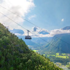
The Rampestreken viewpoint lies 537 meters above sea level and offers amazing views over all of Åndalsnes. You’ll start your trip from the centre of Ånsdalsnes and follow the route to Nesaksla. The trail consists of stone steps made from sherpa stones, and there are also handlebars to hold on to as you go. After you have walked for about 1,5 hours you’ll reach Rampestreken. This viewpoint consists of a 20 meter long steel ramp, where the last 8 meters go straight into the air! When you are done enjoying the view you can continue walking for another 15-30 minutes up to Nesaksla, where you’ll find plenty of hiking and bike trails plus a restaurant where you can enjoy a nice local meal before heading back down. The Romsdalen Gondola goes from Åndalsnes all the way up to Nesaksla, making it easy to combine a hike to Rampestreken with a gondola ride. This is the longest skylift in Norway and offers amazing views over the peaks and valleys as you go.
Trollstigen view point
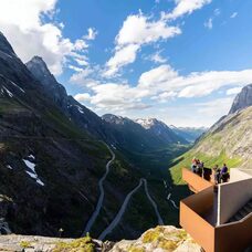
From the Trollstigen viewing platform you can enjoy a fantastic view of the dramatic mountain landscape. It is also a good starting point for several mountain hikes in the area, such as Bispevatnet, Stabbeskaret and Kløvstien, as well as the iconic mountains Bispen Kongen and Dronninga.
Bispevatnet
A short hike to Bispevatnet offers a lovely view of the lake and the surrounding mountains. The path is well marked and the length is about 4 kilometers round trip. This trip is graded with an easy level of difficulty and offers great nature experiences without putting in too much effort.
Stabbeskaret
A slightly more demanding trip that offers fantastic views over Isterdalen and Trollveggen. The path is quite steep at times, and you have to use your hands to get up certain parts. The length of the trip is approximately 6 kilometers round trip. A great hike suitable for the experiended mountain hiker.
Kløvstien
Follow a historic path that was once used as a commuter route between Romsdal and Sunnmøre. Before the Trollstigen road opened, this route was used to transport horses and cows to the market. This is a demanding but beautiful trip lasting for about three hours.
Bispen, Kongen og Dronninga
Kongen, Dronninga and Bispen are three well-known peaks in Åndalsnes. You can hike to Bispen (1462 above sea level) in about 3-5 hours. You can also extend the trip and continue to Kongen and Dronninga.
Kongen is a bit of a tougher hike, taking about 6-8 hours to complete. After reaching this peak you can continue to Dronninga (1544 meters above sea level). Whether you hike to Dronninga from Kongen or from the parking lot in Vikdalen, this is a long trip (8-10 hours). All peaks offers amazing views.
Romsdalseggen
Romsdalen – one of Norway's most beautiful hikes takes about 6-8 hours to complete. On this 10 kilometre hike you will pass well-known spots such as Trollveggen, Romsdalshorn, the Isterdal Valley, the Rauma River, the Bishop, the King and the Queen before reaching Nesaksla. From here you can walk back down to Åndalsnes and stop by Rampestreken viewpoint on your way down, or you can catch a ride with the Romsdalen Gondola.
Litlefjellet
Litlefjellet is a light version of Romsdalseggen, easily accessible for most and very family friendly. It only takes about 20-30 minutes to walk from the starting point and at the same time you get amazing views of Trollveggen, Trolltindene, Åndalsnes and the Romsdal Fjord. This hike gives you a lot of reward for very little effort. You can join a hike to Litlefjellet, bring your lunch and enjoy some of the wildest nature Norway has to offer.
The route is marked throughout and it’s easy to find your way. The trip starts in Venjedalen, about one kilometer from Vengedalsvatnet. The beginning is quite steep but it’s a very defined trail and therefore not the hardest of walks. You’ll be walking about 140 meters upwards to Litlefjellet, which lies 790 meters above sea level.

